Discover hiking on El Hierro: Nature Trails and Scenic Treks

Arenas Blancas
Just like on La Gomera and La Palma, you can make fantastic hikes on El Hierro, and El Hierro hiking is magnificent. Although El Hierro is the smallest island of the Canary Islands, there are many beautiful hiking trails on El Hierro. And every hike is really different, there are nature walks on El Hierro, but coastal walks and vulcano hikes as well, it is all possible. Read about El Hierro hiking in this blog and we highlight three hikes that we did, simply because we experienced them as fantastic.
On El Hierro you can enjoy fantastic walks and hikes. The island may be the smallest of the Canary Islands, but it offers a lot of possibilities. This has to do with the very diverse landscape and the changing weather conditions as a result. At sea level and along the coast the weather is often nice and warmer, but when you get to altitude it is often cloudy and foggy and a lot cooler. And on El Hierro there is a large mountain wall that rises almost steeply. With a wide valley on the north side and a somewhat smaller but also steep valley on the east side. And on ridges of the mountain side there are some flatter parts here and there and then it suddenly goes straight down. At the southern tip is an area that is really rocky and vulcanic. In short, many factors that ensure that a great diversity of hikes is possible.
On the website of Senderos de El Hierro, “the hikers of El Hierro”, all trails are described and shown on a map. Just like on La Gomera and La Palma, a distinction is made between linear routes (from A to B) and circular routes. And there is a difference in difficulty, there are short walks, medium and long. The main and longest trail on the island is the GR-131 from Tamaduste on the northeast coast to Faro de Orchilla on the southwest coast. This route is 37.7 kilometers long with an altitude difference of 1500 meters and it is recommended to do it in two days. In our blog about Pico de Malpaso we already described that we did part of this hike. In addition to this long trail, there are therefore various options for shorter and longer trails. But you can also make very good combinations of different trails if you plan well in advance.
One of the most walked hikes on El Hierro is the “Sendero de La Llania”. This is one of the least strenuous hikes, but a very nice one. It is a hike at altitude, between 1320 and 1400 meters through the green part of the mountains and a part through the vulcanic landscape. We will write a separate blog about this hike. In this blog we describe three other hikes, because they are really great and we really recommend them.

Mirador de Jinama
The reward at the end of the Jinama climb is a stunning view of El Golfo
The first is the most beautiful but also toughest hike in our experience. It is the climb to the Mirador de Jinama, a viewpoint at 1240 meters altitude. The climb is part of the official trail PR EH-8, which runs from Las Puntas at sea level to San Andres in the mountains. The tough and most beautiful part, the climb and/or descent to and from Jinama, runs from the church Ermita de Virgen de los Reyes in La Frontera at just over 400 meters altitude to the Mirador de Jinama and is 4.4 kilometers long with a height difference of more than 800 meters. That is a high average ascending percentage. We did both the descent and the climb once. Both to gain the experience and also because the one time it was foggy and the other time nice weather. During the climb the weather was nice and during the climb you always have fantastic views over the enormous valley El Golfo. You are continuously climbing through the greenery against the vulcanic mountain. And when you come up on Jinama you probably have the best view of the island, and some even say the best view of the Canary Islands. The climb is tough but if you're fit you can do it, the views are phenomenal and you hike through a beautiful green and vulcanic mountain landscape.

Climb to Jinama
The climb to Jinama is a tough one but it is worth every climbing step
The second hike that we want to highlight is the one across Arenas Blancas and along the coast. Arenas Blancas is a sprawling spur of the vulcanic landscape at the extreme western tip of the island. This entire western tip has a vulcanic and rocky character with high cliffs on the coast. When the wind is blowing and the sea is rough, which is often the case here, the spectacle of the waves crashing against the cliffs is fantastic. You can see it all if you hike the trail SL EH-3 from Arenas Blancas along the coast in a southwesterly direction. The trail is just 2.7 kilometers on a path through the vulcanic landscape and along the rocky cliffs and is easy to walk for everyone. But because you are always surprised by beautiful views, the violence of the sea, the beauty of the landscape and the changing view of the mountains and vulcano, you can easily do it for a few hours. We ended up wandering around for a whole afternoon, also occasionally off the path. But what a great hike, and the great thing is that it is really doable for everyone.
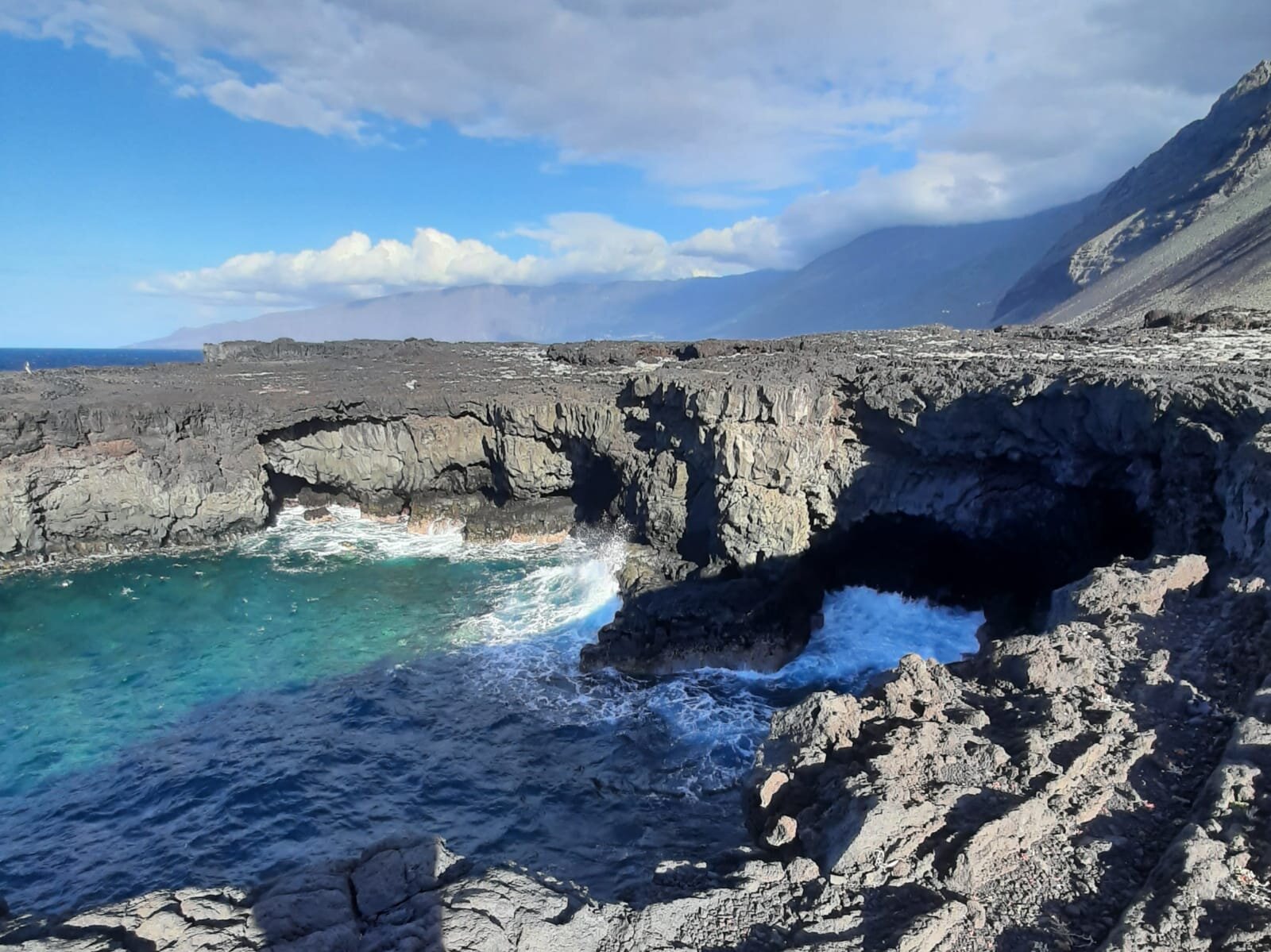
Arenas Blancas coast
The coastline is raw and spectacular when the sea is rough
The last hike we would like to mention is the one to and through El Julan. That is an area along the south coast that actually runs from Faro de Orchilla to Tacoron. It is an area where no one lives and it is pure and untouched nature. The area is characterized by the southern foothills of the vegetated vulcanic landscape. We hiked the route PR EH-10 which officially runs from Piedra de los Regidores to Taibique and is 17.5 kilometers long. The hike is largely entirely between 700 meters and 1000 meters altitude, but goes up and down quite a bit here and there. From the trail we hiked about 10 kilometers back and forth and that is very nice to do. Because you see the environment differently from both sides along the trail. On the trail you have large parts with the Atlantic Ocean on one side and the vulcanic mountains on the other. And then hiking a trail from both sides is sometimes a bonus because you see so much more. But beware, it can be foggy or cloudy at this altitude so keep that in mind when you go hiking here.

El Julan
When hiking through El Julan you have fantastic views along the southern coastline
Besides the hikes to Pico Malpaso and La Llania described in other blogs and these three hikes, you can do many more fantastic hikes on El Hierro. Just like La Gomera and La Palma, El Hierro is a real hiking paradise. All islands have their own charms and challenges in that regard. And for El Hierro this is due to the variety, the sometimes heavy and steep parts, but also the possibilities for a shorter and easier walk, just along the coast.
Do you like hiking……., El Hierro is a place to be!
And for more photo material and information about hiking on El Hierro, check out our Instagram posts and our Polarsteps page!
Ella & Geert.